

Norton Line Slope Stabilization
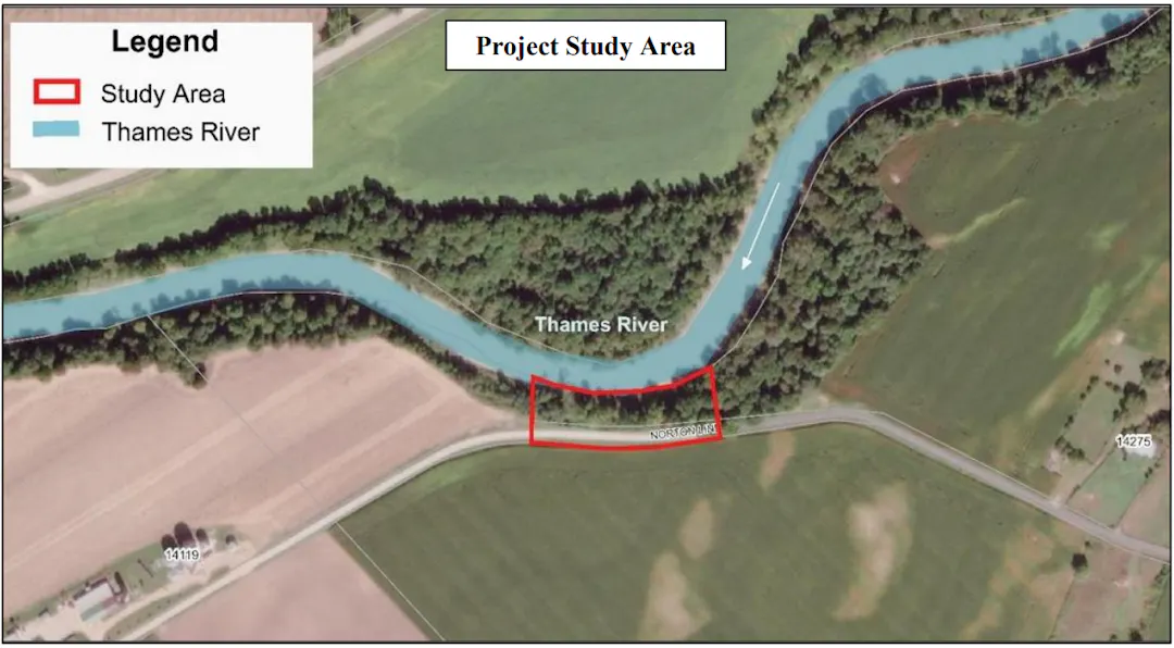
In 2019, a climate analysis report was completed noting growth in intense rainfall events causing increased flooding within Chatham-Kent. Significant storm events can exacerbate erosion and threaten private property and municipal infrastructure. Since the report, several study areas were identified that show signs or have experienced significant erosion, slope failure, and bank regression. One of the identified study areas is located adjacent to a section of Norton Line, which is at risk as a result.
The Municipality of Chatham-Kent has since retained the Engineering Services of Aquafor Beech Limited (Aquafor) to complete a 'Schedule B' Municipal Class Environmental Assessment (MCEA) and design to assess the slope stability of approximately 200 meters of riverbank along the Thames River, near 14275 Norton Line, in the Community of Orford. The initiation of the MCEA is to identify preferred approaches to address slope stability concerns with the Study Area, as well as develop designs to mitigate further slope failure and bank regression.
Project Scope
To support the MCEA, several investigations will be undertaken at the study area which include but are not limited to the following:
Topographic Survey: Non-invasive walkover detailed land survey that maps the natural and man‑made features of a site, recording horizontal positions and elevations to show the shape (contours) and characteristics of the terrain using GPS/GNSS surveying devices.
Pre-Engineering Field Utility Locates: Non-invasive field investigation to identify and mark the approximate locations of underground utilities, including water, gas, hydro, telecommunications, and sewer services, using specialized detection equipment to support planning and design activities.
Closed-Caption Television (CCTV) Inspections: Inspection of existing underground sewer infrastructure using remotely operated camera equipment to visually assess pipe condition, identify defects, and confirm alignment, supporting planning and design activities.
Natural Heritage Investigations: Non-invasive walkover surveys to verify habitat features and their functions;
Geotechnical Investigation: Non-invasive walkover survey to identify and locate underground infrastructure prior to the subsurface investigation. Including confirming points of access for geotechnical fieldwork, including;
Drilled boreholes: The boreholes will be advanced with a track mounted drill rig. Borehole locations shall be restricted to the Municipal Right-of-Way (ROW) and will not impact private lands.
Archaeological Assessment (AA) Stage 1: Background study and property inspection to review existing information and assess the potential for archaeological resources, including a review of historical records, land use, and a visual site assessment, to inform planning and design activities.
These above noted investigations/studies will aid in the preparation of alternative solutions to be presented to the public, property owners, indigenous communities, and government agencies through various channels including a Public Information Centre (PIC), where community members will have the opportunity to view and provide comments to the alternative solutions for the Municipality and Aquafor to consider when determining the preferred solution. Once the preferred solution has been determined, Aquafor will proceed with the detailed design phase which will also provide an opportunity of community engagement through a second PIC, before proceeding to the construction phase and project closeout.
The MCEA is expected to be completed by Fall 2027 with construction to follow.
Your Feedback is Important!
To submit a question or comment, or if you have accessibility requirements to participate, please contact a member of the project team.
-

Phone 519-360-1998 Email ck311@chatham-kent.ca -

Phone 519-360-1998 Email ck311@chatham-kent.ca -

Email amos.r@aquaforbeech.com
