Queen's Line and Merlin Road Intersection Improvements
Consultation has concluded
Project Description
Chatham-Kent Engineering and Transportation Division received multiple requests to review the intersection of Queen’s Line and Merlin Road. Concerns with the intersection include: the lack of sight lines for opposing left turn vehicles on Queen’s Line; hazardous maneuvers involving vehicles passing to the right of stopped vehicles attempting to make a left turn, and difficulty making left turn and crossing maneuvers from Merlin Road.
A review of the intersection was completed by Chatham-Kent staff and the analysis indicated:
- Left turn lanes are Warranted on Queen’s Line in both eastbound and westbound directions.
- Left Turn lanes are Not Warranted on Merlin Road.
- A traffic signal is within 99% of meeting Ontario Traffic Manual warrants and is expected to meet warrant criteria by 2027 through background traffic growth and as a result will be included with the construction of the left turn lanes.
- Consideration has also been given to construct a roundabout as an alternative to the left turn lanes and traffic signals.
Therefore, the Municipality of Chatham-Kent will be moving forward with improving the intersection of Queen’s Line and Merlin Road with one the following intersection design options:
- Re-construct intersection with eastbound and westbound left turn lanes on Queen’s Line with a traffic signal intersection control, or
- Re-construct intersection with a roundabout.
Background
The intersection of Queen’s Line and Merlin Road is located approximately halfway between Chatham and Tilbury. Queen’s Line and Merlin Road are both are two-lane rural arterial roadways. The intersection is controlled by northbound and southbound stop signs on Merlin Road. Both stop signs are enhanced with flashing red beacons. The posted speed limit is 90 km/h on Queen’s Line and 80 km/h on Merlin Road. Both roadways are truck routes. Queen’s Line also functions as an Emergency Detour Route (EDR) for Hwy 401 between Interchange #63 and #81 and therefore can experience significant increases in traffic volume.
Government Drain #1 runs adjacent to the west side of Merlin Road. Queens Line crosses the drain immediately west of the intersection over a ridged frame bridge structure. Merlin Road crosses Highway 401 to the south via an overpass structure. An informal car pool lot and community mailbox are located on the west side of Merlin Road south of Queen’s Line. Figure 1 illustrates the current intersection and surrounding features.
Figure 1: Current Intersection Configuration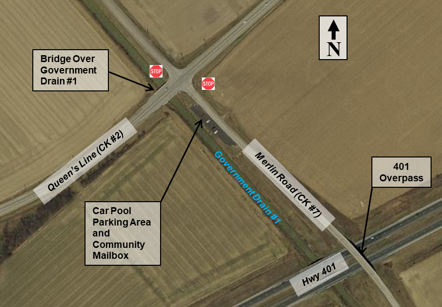
BT Engineering was retained by the Municipality of Chatham-Kent to examine the intersection of Queen’s Line and Merlin Road Intersection. The objective of the review is to identify recommended measures to improve traffic operations and address historic safety concerns at the intersection of these two rural arterial roads.
The report submitted by BT Engineering which provides a detailed evaluation of the intersection and recommended alternative can be found with this link: Queen’s Line and Merlin Road Intersection Operations Improvement Review; September 30, 2021
Improvement Alternatives
There are several challenges that need to be considered for improving the Queen’s Line and Merlin Road intersection, including:
- Meeting current design standards for operational safety.
- Provide the capacity and level of service to accommodate current and future traffic volumes, and volume surges from Highway 401 EDR activation.
- Existing Physical Conditions:
- Location of the Government Drain #1, immediately west of Merlin Road.
- Location of the bridge structure over Government Drain #1, immediately west of the intersection.
- Accommodate large vehicles, including transport tractor trailers and farm vehicles (e.g. combines).Minimize land requirements
Two intersection improvement alternatives have been identified:
Alternative 1 – Single Lane Roundabout
The roundabout, with an inscribed circle diameter (ICD) of 45m would be designed to accommodate the movement of truck traffic and farm machinery through the intersection. The approaches to the roundabout will be designed to reduce vehicle speeds down to a design speed of 45 km/h and entry into the roundabout will be controlled by a yield sign. The reduced entry speeds in turn reduce the sight line requirements down to 40 m. Total land acquisition requirements for this alternative is approximately 4,100m2.
Figure 2 illustrates the potential configuration of the roundabout alternative, including sight line and property requirements. A high-resolution version of Figure 2 is provided in the documents section of this webpage.
Figure 2 – Roundabout Configuration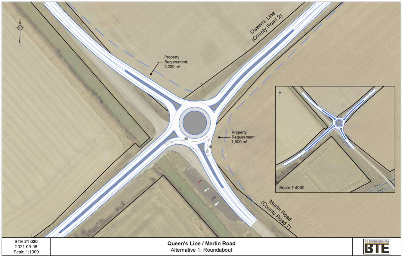
Alternative 2 – Traffic Signalization and Eastbound and Westbound Left-turn Lanes
For the traffic signalization alternative, the Transportation Association of Canada (TAC) requires a specified sight distance based on design speed. For a design speed of 100km/h, based on the 90km/h posted speed limit on Queen’s Line, a clear sight triangle of 210m in both directions along Queen’s Line is required. A visibility hazard for this alternative will be the parapet walls and guiderails located on each side of the bridge. Achieving the required sight visibility triangle would require either:
- Realignment of Merlin Road to increase the spatial separation of the intersection from the existing bridge structure; or
- A further widening of the existing bridge, to accommodate the provision of left-turn lanes and to extend the parapet walls beyond the TAC sight triangle standard.
Widening of the structure over Government Drain #1 was not carried forward for further consideration due to the larger construction costs, as well as the higher long-term maintenance costs associated with overbuilding the structure.
In order to accommodate the required sight distance beyond the existing bridge structure, the intersection would need to be shifted northeast, which would require additional land acquisition. Total land acquisition requirements for this alternative is approximately 18,700m2.
Figure 3 illustrates the potential configuration of the traffic signal eastbound and westbound left turn lanes alternative, including sight line and property requirements. A high-resolution version of Figure 3 is provided in the documents section of this webpage.
Figure 3 – Traffic Signal Configuration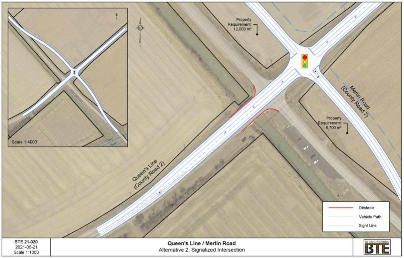
Evaluation of Alternatives
1. Construction Cost: Preliminary cost estimates have been developed for the three alternatives as follows:
- Alternative 1 – Roundabout $2.1 million
- Alternative 2 – Traffic Signal control with realignment of Merlin Road $2.9 million
- Alternative 3 – Traffic Signal control with widening of the existing structure $5.4 million (not carried forward)
Favours Roundabout
2. Future Longer Term Operational Costs: These are annual lifecycle and maintenance costs required after the intersection is reconstructed. Both alternatives will have similar roadway lifecycle costs (e.g. asphalt, curbs, etc.). The traffic signal has additional costs, including traffic signal equipment lifecycle costs and regulated inspections twice a year, and regular maintenance items (burnt out lamps,
Favours Roundabout
3. Traffic Operation: Traffic signals may provide a more conventional operation for drivers but would result in longer delays for the majority of traffic, particularly on the east and west legs of the intersection. Capacity analyses of both alternatives was completed.
Although both alternatives (roundabout or traffic signal control) would provide a good level of
service, the operation of a roundabout would be superior. Roundabouts share all available gaps to all drivers arriving at the intersection, and a roundabout would also be better able adjust to sudden
peaks in the traffic demands resulting from Queens Line’s functioning as an Emergency Detour Route.
Favours Roundabout
4. Traffic Safety: From a traffic safety perspective, roundabout control offers significantly fewer conflict points than a conventional intersection, and can be expected to have 67% fewer collisions and 75% less severity with those collisions. Figure 4 compares the collision conflict points of a typical 4-leg intersection to a roundabout. 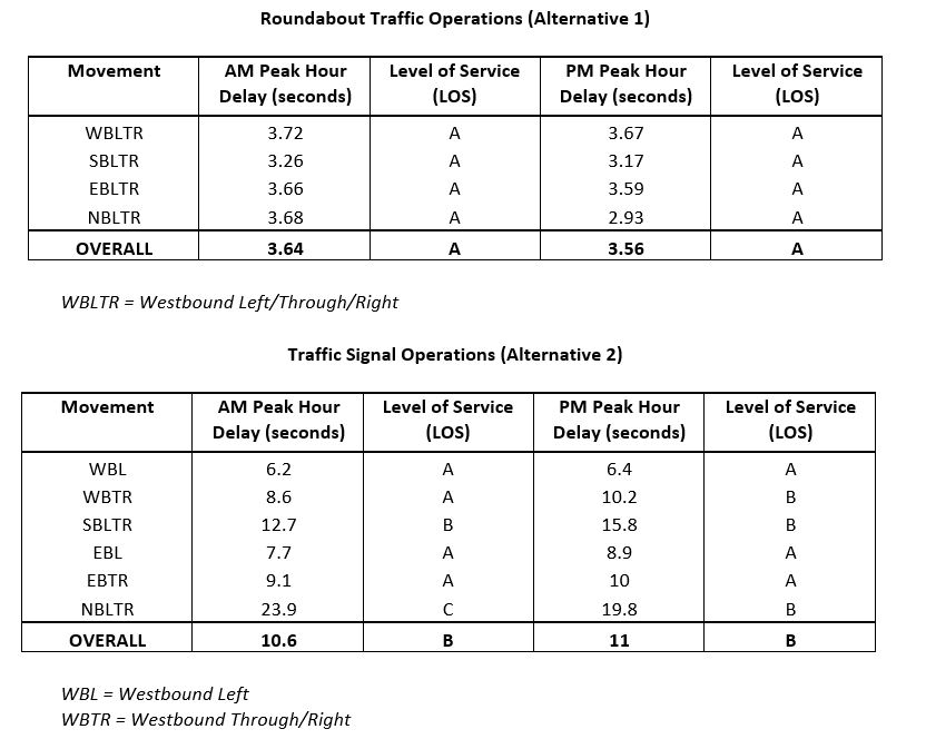
Figure 4 – Collision Conflict Points Comparison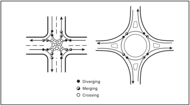
Favours Roundabout
5. Property Impacts: The loss of property and impacts to property owners is often a main reason for choosing signalized intersection control. However, at this location, the required realignment of Merlin Road to meet geometric design standards for a signalized intersection would result in significantly greater property impacts
- Roundabout Land Acquisition Requirements – 4,100m2 (approx.)
- Signalized Intersection Land Acquisition Requirements – 18,700m2 (approx.)
Favours Roundabout
6. Design Consistency: Providing design consistency on a roadway alignment improves its safety due to driver familiarity. The realignment of Merlin Road to accommodate the placement of traffic signals would require a curvilinear alignment, which would include a minimum radius horizontal curve with limited visibility for northbound motorists, and would further add to the potential hazards approaching the intersection.
Although a roundabout control would be the first in Chatham-Kent, advance visibility would exist on all approaches.
Favours Roundabout
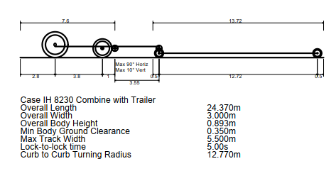
7. Accommodating Large Agricultural Machinery and Transport Trucks: Both designs would be developed to accommodate both large transport trucks and large combines. The roundabout design criteria would be based on accommodating large combines with an overall length of 80 feet and tandem tractor-trailer units.
Figure 5 and 6 illustrates the wheel path of a typical combine harvester with a head trailer through a roundabout and the dimensions of these vehicles. A high-resolution version of Figure 5 is provided in the documents section of this webpage.
Figure 5 – Roundabout Oversized Vehicle Operation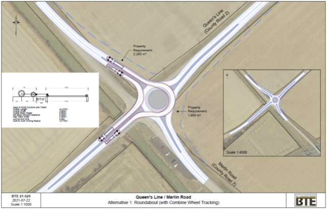
Figure 6 – Typical Combine Harvester Dimensions
Favours Both Alternatives
8. Approval Requirements: The realignment of Merlin Road that would be required to accommodate traffic signals would impact the existing fill slope on the north side of the MTO structure over Highway 401. This would require MTO approval.
Favours Roundabout
Recommendations
To better accommodate the existing traffic demands and improve safety, the provision of a roundabout at the intersection of Queens Line and Merlin Road is recommended. A summary of the evaluation is provided below: 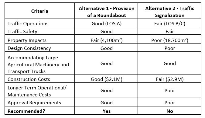
Process
The key tasks required in order to complete this project include:
- Task 1: Retain Consultant for Review of Alternatives and Provide Recommendation - Complete
- Task 2: Virtual Public Information Centre (PIC) on Let’s Talk Chatham-Kent – On-going
- Task 3: Consolidate Community feedback
- Task 4: Recommendation Report to Council providing the desired Alternative
- Task 5: Land Acquisition as required
- Task 6: Retain Consultant for Detailed Design and Contract Administration
- Task 7: Retain Contractor for project construction
Public Consultation
The purpose of the virtual Public Information Centre (PIC) is to present the existing conditions and consultant recommendations to the public. It also provides an opportunity for the public to share their input on the proposed design alternatives that have been presented. The Municipality of Chatham-Kent wants anyone with an interest in this project to have an opportunity to provide input. Feedback is always welcome.
The virtual PIC will be posted on the Municipality’s Let’s Talk website from Thursday December 2, 2021 to Thursday December 23, 2021. Comments and recommendations will be collected from the public while the PIC is active.
All comments received during this period will be reviewed by the project team following the conclusion of the virtual PIC. Comments will be received through the website or can be submitted to the contacts listed on this page. The Consultant report, as well as the Public comments will help the project team and Council in the decision-making process.
Figure 7 – Roundabout Concept Illustration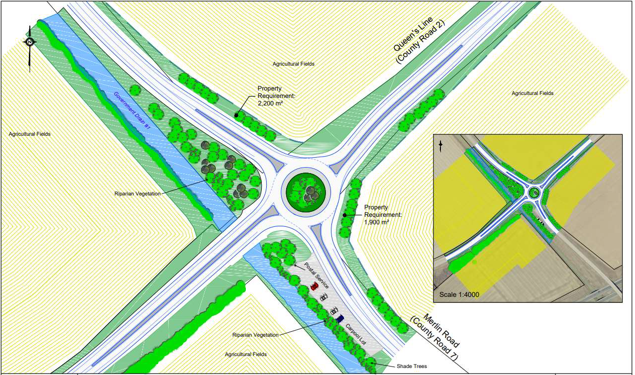
-
Manager, Engineering (Traffic & Underground Infrastructure)
Municipality of Chatham-Kent
Phone 519-360-1998 Email ckinfo@chatham-kent.ca -
Engineering Technologist
Phone 519-360-1998